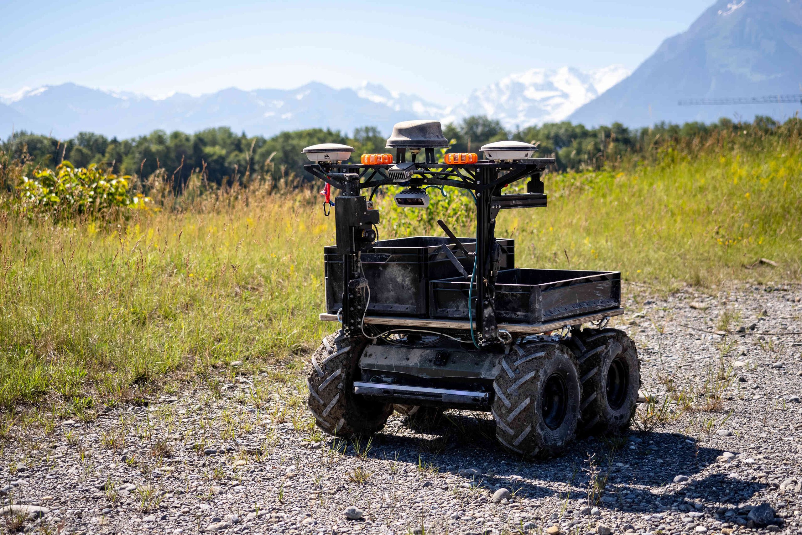
Our ELROB 2026 configuration, set up for outdoor logistics. The Outdoor Navigation Package is the front sensor frame. The cargo box, the Follow Me module and the custom colour are separate options and are not part of it.
Outdoor Navigation Package
Panther and Lynx already handle the terrain. This package lets them drive the route without an operator.
One front-mounted assembly carries dual-antenna RTK GNSS, a 360° 3D LiDAR and a depth camera. Husarion's sensor fusion keeps localisation continuous as the robot moves from open sky into GNSS-denied ground, so there is no mode switch and no hand-off to the operator when it drives between buildings or under tree cover.
You do not integrate any of it. The robot arrives with the package mounted, calibrated and validated, and the mission UI runs in a browser on the robot itself.
1 cm
RTK position accuracy, with a fix
2
GNSS antennas for true heading
360°
3D LiDAR coverage
10 cm
route repeatability, lateral, good RTK
0
Husarion cloud services in the loop
120 kg
Panther rated capacity, less the package
The problem it solves
Somebody is walking a load between two points, several times a day, on the same route. Or driving a vehicle that is bigger than the job needs. The robot does that trip instead: show it the route once, and it repeats it for as long as the work lasts.
Getting a robot to do that reliably outdoors is harder than it sounds, and it usually comes apart on integration rather than on algorithms. Three things account for most of it.
A single GNSS antenna gives position but no heading. A magnetometer sitting next to four BLDC motors and a steel chassis drifts badly, and gyro or wheel odometry drifts over time, so the robot ends up confidently facing the wrong way.
RTK is excellent under open sky and useless between buildings or under dense canopy. Systems that switch between GNSS and LiDAR modes tend to lurch at the boundary, which is usually where the route is tightest.
Then there is everything else: correction services, satellite map layers, time synchronisation, extrinsic calibration, mounting that survives vibration. Each one is solvable on its own, and together they are what tends to push a pilot's schedule out.
This package covers all three as one delivered configuration.
What's on the robot
The package is the front sensor frame and the computer behind it. Everything else is the standard platform, or equipment you choose separately.
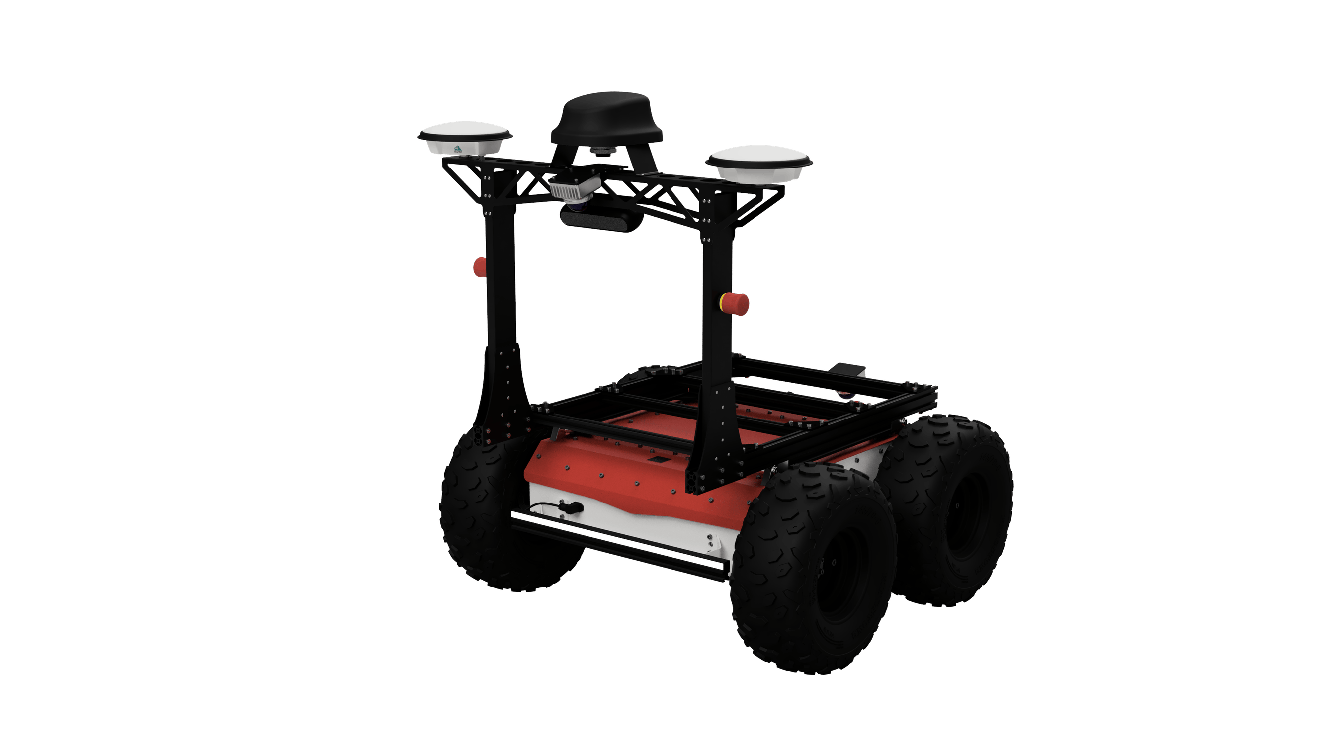
The Outdoor Navigation Package on a standard Panther, in standard livery. This is what the package on its own looks like.
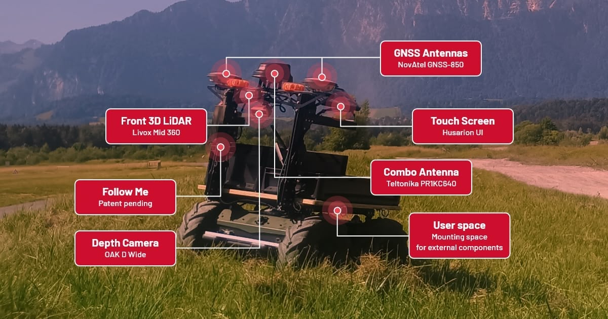
The ELROB 2026 build, with the package components labelled. The cargo box, Follow Me and the custom colour are separate options and are not part of the package.
| Component | Part | Why this one |
|---|---|---|
| GNSS antennas | 2 × NovAtel VEXXIS GNSS-850 | Multi-constellation, multi-frequency. Phase centre stability under 2 mm, patented multi-point feed with multipath rejection, low-elevation tracking for tree lines and urban canyons. MIL-STD-810G shock and vibration, IP69K sealed, −40 °C to +85 °C, per the NovAtel datasheet |
| GNSS receiver | u-blox ZED-F9P | L1 / L2 / L5, RTK accuracy 0.01 m + 1 ppm CEP, convergence under 10 s. Moving-base mode with the two antennas produces heading directly |
| 3D LiDAR | Livox Mid-360 | 360° horizontal coverage for localisation and obstacle detection where GNSS cannot reach |
| Depth camera | Global-shutter depth camera | Close-range perception in front of the robot. The model is confirmed at order, because we qualify the sensor per production batch |
| Connectivity | Teltonika PR1KC640 combo antenna | Mobile internet for correction services and remote access |
| Operator interface | Browser UI, hosted on the robot | Mission planning from any laptop on the network |
Two antennas on a fixed baseline let the receiver compute absolute heading from the geometry between them. It is available the moment the robot powers on and it does not drift. That matters most on a robot which spends much of its time stationary or moving slowly, where there is no motion to infer a heading from.
Mission modes
| Mode | What the operator does |
|---|---|
| Navigate Through Poses | Continuous path tracking. Draw the path on the map, or record it by driving the robot manually once, then replay it as often as the mission needs |
| Navigate Through Waypoints | Sequential multi-stop missions, with a configurable dwell time or a specified action such as taking a photo at each point |
| Navigate to Pose | One click to a target pose |
Recording a route and replaying it are functions of this package. Follow Me is one way to feed it: the operator walks the route, the tether reports where the operator is, and this package turns that into a drivable line it can repeat. It works at night and in dust, where camera-based teach-in degrades. This is the workflow we ran at ELROB 2026.
Follow Me is currently offered through our Field Evaluation Program rather than general order. Route teach-in by driving the robot manually is available today, and works with any of the mission modes above.
How accurately does it repeat a route?
On a route replayed under good RTK conditions, the robot tracks the taught line to within about 10 cm laterally. That is the figure that matters for planning: it tells you whether a route fits down a service road, past a loading bay, or between two parked vehicles.
Note that this is a different number from the 1 cm RTK position accuracy quoted for the GNSS receiver. The receiver knows where it is to a centimetre. The package then has to steer a physical vehicle along a line, over terrain that pushes it around, so path error is larger than position error. Anyone quoting sensor accuracy as path accuracy is quoting the wrong number.
Deviation grows where RTK degrades, on loose or heavily cambered surfaces, and at higher speed. During commissioning we tune the configuration on your ground: correction setup, speed and cornering limits for the surfaces you actually drive, and the stopping margins that suit your site.
Where GNSS drops out
Losing satellite coverage is what usually breaks an outdoor mission: the robot drives under a canopy, between two buildings, or briefly indoors, and the localisation it was relying on stops being trustworthy.
This package carries the robot through those gaps using visual and inertial odometry from the onboard camera and IMU. There is no mode switch and no operator hand-off. The mission keeps running.
Be clear about what that is and is not. It bridges a gap in an outdoor mission; it is not an indoor navigation system, it builds no map of the building, and the longer the gap, the further the estimate drifts. If your mission is substantially indoors, that is a different problem and worth talking through before you buy.
Mission UI, hosted on the robot
Point a browser at the robot's IP address and plan on a live map view. The UI is hosted on the robot: no cloud service of ours, no Husarion account, no vendor lock-in. Mission planning and execution do not depend on anything of ours being reachable.
RTK corrections are separate. Centimetre-level positioning needs a live NTRIP feed from a correction service, which means internet access and an account with that provider. That is a third-party dependency, not one of ours, and the robot still navigates without it at reduced absolute accuracy.
Your own code alongside it
The package exposes a ROS 2 API for commanding missions and reading state, so your application can drive it rather than replace it. You do not modify the navigation stack itself, which is what keeps it something we can support and calibrate.
Tell us what you intend to run and we will go through where it should sit on the robot as part of the deployment conversation.
Built-in safety
The robot stops automatically for obstacles it detects. Detection is bounded by the field of view of the LiDAR and depth camera, and we establish the working envelope for your site during commissioning. A software E-stop can be triggered and reset from the UI. Panther and Lynx also keep their own hardware E-stop on the robot, independent of any package (Panther, Lynx).
The package provides operational safety functions. It is not a certified functional-safety system and carries no performance level or safety integrity level rating. Deployments around people require your own site risk assessment.
Field record
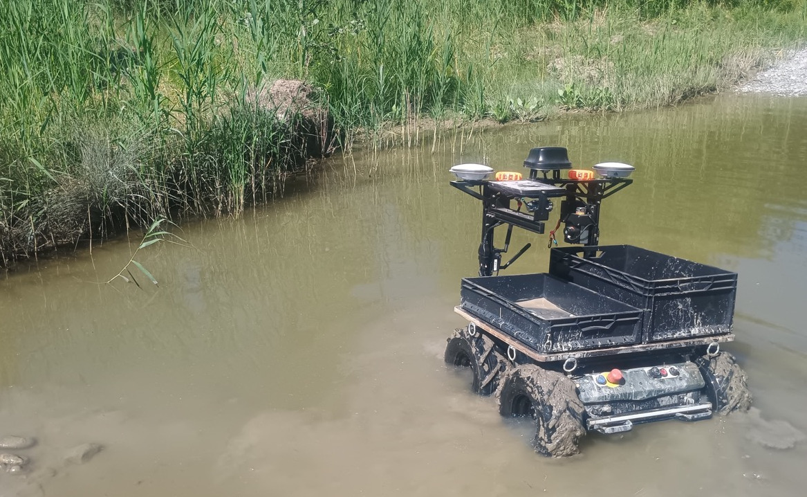
The same ELROB 2026 configuration. The navigation package is the sensor frame at the front.
At ELROB 2026, the European Land Robot Trial, we ran this package on Panther in the Transport-Mule scenario: a shuttle mission between two points roughly 300 m apart in non-urban hill terrain in Switzerland, among the 21 teams in the field, alongside Diehl Defence, Rheinmetall, L3Harris and TNO. The route was taught by walking it with Follow Me, then replayed autonomously.
One full shuttle cycle completed, with one terrain-related safety intervention on a steep uneven section. A second cycle was stopped by a barricaded gate. Replanning around a blockade like that was part of the trial, but it is outside the scope of this package today.
We publish that because an operator had to step in, and you are likely to meet the same terrain.
Where it fits, and where it doesn't
It is designed for repeatable outdoor missions on structured and semi-structured terrain: gravel and service roads, industrial sites, campuses, farms, test ranges, logistics paths, and the transitions between outdoor and indoor space.
Ask us first if your mission involves highly unstructured off-road driving, routes that are frequently blocked and need complex dynamic replanning, or environments with neither usable GNSS nor stable LiDAR structure. None of these rules the package out, but they need a use-case review before anyone commits to a deployment date.
If emissions matter, weigh this against Follow Me on its own. This package senses and communicates actively: the LiDAR scans, and the mobile link transmits to reach the correction service. Follow Me by itself emits nothing at all. If a low signature is part of why you are looking at tethered following, adding this package changes that trade, and it is better raised now than at commissioning.
What we do, what you provide
We deliver the robot with the package mounted, calibrated and field-tested, the mission UI running on it, the configuration tuned to your terrain during commissioning, and the full manual and setup documentation.
You provide the site and these three things:
| Internet access, mobile or fixed | To reach an NTRIP correction service. Corrections are streamed live, so this connection has to be up while you need centimetre-level accuracy |
| NTRIP correction service | Strongly recommended in open terrain, because centimetre-level RTK depends on it. Without corrections the system still runs, at reduced absolute accuracy |
| Satellite map layer | To show the site under your route when you plan a mission in the UI |
Common questions
What does it cost? We quote per configuration rather than publishing a price. What moves it: the platform, whether you already own the robot, the options you fit alongside the package, and how much commissioning your site needs. Tell us the mission and we will come back with a figure and a date.
How much of my payload does the package itself use? We have not published the package mass yet. The mounting is designed so the user compartment and the space above it stay free, but the hardware still comes out of the platform's rated capacity, and we confirm the exact figure at quotation. If your payload budget is tight, say so early and we will get you the number before you order.
What if it does not work on my site? Tell us the terrain, the route and the GNSS conditions before you commit to anything. A use-case review costs nothing, and it is considerably faster than a pilot that fails in week three. Where we think the package is a poor fit, we say so.
Compatibility and ordering
| Platforms | Panther, Lynx |
| Order code | NAV01P on Panther, NAV01L on Lynx |
| Mounting | Front assembly. The user compartment and the space above it stay free for your payload. Package mass comes out of the platform's rated capacity, 120 kg on Panther and 65 kg on Lynx; we confirm the figure at quotation |
| Combines with | Follow Me and the standard configuration options |
| Delivered | Mounted, calibrated and field-tested by Husarion |
| Lead time | Typically 8 to 16 weeks, depending on configuration and the current queue. Sensor availability is the usual constraint and can extend it, so ask early if you have a fixed date |
| Retrofit | Yes, to a Panther or Lynx you already own. The robot returns to us for mounting and calibration, so allow for shipping and downtime |
| Autonomous limits | Speed matches the platform: 2 m/s on Panther, 1.5 m/s on Lynx. Slope does not. Ground steep enough registers as an obstacle, so the robot stops well below what it climbs under manual control, which is 44° on Panther at 52 kg of cargo and 28° at 100 kg. We establish the workable figure for your terrain during commissioning |
| Warranty | 1, 2 or 3 years, per the standard warranty options |